BWS INITIATIVES
Content on this page was created and archived before the Americans with Disabilities Act (ADA) Title II mandate for WCAG 2.1 Level AA content and will not be updated for accessibility.
To request special assistance to review or inspect an archived document, call (808) 748-5041, email a detailed request to contactus@hbws.org or submit a request for information form.
Watershed Studies
Watershed Prioritization Study
Updated: July 2013
The Board of Water Supply utilized scientific methods to prioritize watersheds on Oʻahu from a water supply perspective. This effort resulted in identifying the most important watersheds that provide critical sources of fresh water supply, enabling BWS to focus watershed management efforts and funding.
Mākaha Valley Rainfall Canopy Interception Study
Updated: December 2022
A primary goal of the BWS is to ensure an adequate supply of fresh water for current and future generations. In this regard, the capacity of Oʻahu's watersheds to capture and store precipitation is critical: it is the sole natural source of fresh water supply for the island. Our BWS Canopy Interception Study attempts to quantify differences in rainfall capture between native and invasive forests found in the Wai'anae Mountains. This aspect of the water budget of Oʻahu's watersheds (and of watersheds in general) has not been well-studied.
Until recently, the only similar research in Hawaii was located in high-elevation "cloud forest" terrain on the island of Hawaii, where fog drip is a primary component of precipitation. Because that research was not representative of the majority of forested areas on Oʻahu, this study was established as a first step to address Oʻahu's forests.
Improved understanding of native versus invaded forest rainfall capture on Oʻahu will further enable BWS to focus watershed management efforts and funding appropriately.
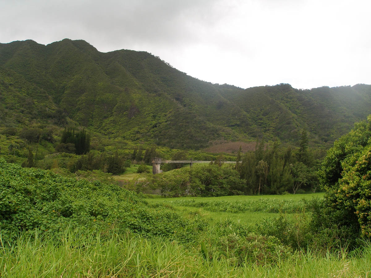
Ko'olau Rainfall Canopy Interception Study
Updated: May 2023
This study serves as a companion to the Mākaha Valley Rainfall Canopy Interception Study. Together, these studies compare rainfall capture between mid-elevation native and invaded forest in the Ko'olau Mountains and the Wai'anae Mountains.
Mākaha Valley Biocontrol of Strawberry Guava
Updated: July 2026
The BWS Watershed Program works to ensure an adequate supply of fresh water for current and future generations, by protecting the ability of Oʻahu's watersheds to capture and store rainfall in the aquifers below. This ability is critical, as rainfall is the sole natural source of fresh water supply for the island. One of the methods BWS employs to protect the watersheds is to reduce the spread of invasive plant species which are considered to be high water users, taking up rainfall that would otherwise be percolating into the ground and recharging the water supply aquifers.
Strawberry guava (Psidium cattleianum) is considered to be one of the most destructive invasive plant species in Hawaiʻi. This species was brought to Hawaiʻi in 1825 for its fruit and ornamental attributes. Due to a lack of natural predators and diseases in Hawaiʻi compared to its native Brazil, the plant has spread rapidly across the islands via both shoots and seeds, replacing many hundreds of thousands of acres of native forest with monotypic stands of the plant. For native forest replaced by strawberry guava, the rainfall lost to groundwater recharge due to this plant, is thought to be around 25 percent of total rainfall.
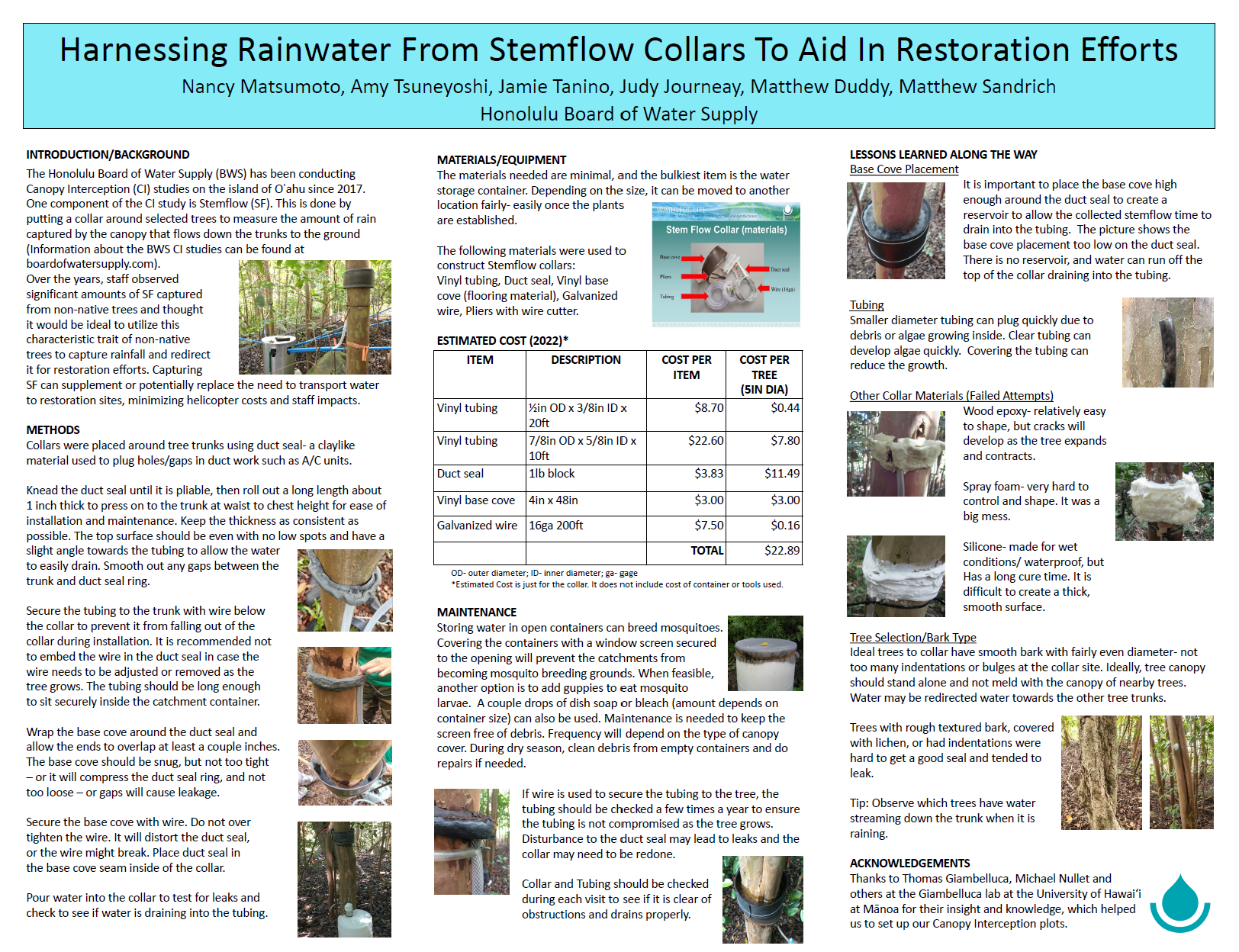
Harnessing Rainwater from Stemflow Collars to Aid in Native Forest Restoration Efforts
Posted: February 2025
This research evolved from the BWS Canopy Interception (CI) studies in the Waiʻanae and Koʻolau Mountains. Field methods were developed to design and install stemflow collars, which capture rainfall flowing down the trunks of trees (a.k.a., stemflow). Optimizing the design and installation of these stemflow collars resulted in efficient stemflow water collection. These methods could be easily adapted to capture water needed for native forest restoration sites, minimizing the need to transport large amounts of water for irrigation to remote areas (e.g., via helicopter).
Ala Wai Watershed Study
The Ala Wai Watershed Study is a joint-agency flood and ecosystem management study lead by the Army Corps of Engineers with State and County involvement. For more information, visit the Army Corps of Engineers' Ala Wai Canal Project page.
Central Oʻahu Watershed Study
The Central Oʻahu Watershed Study was an overview of watershed information pertinent to the area and will be used by the BWS to develop Watershed Management Plans for the Central Oʻahu and ʻEwa Development Plan areas, and parts of the Primary Urban Center. Using this overview, resource problems and issues were identified. Potential projects and programs to remediate these issues were then investigated and outlined.
- Central Oʻahu Watershed Study - Final Report
- Central Oʻahu Watershed Study - Appendix A
- Central Oʻahu Watershed Study - Appendix B
- Central Oʻahu Watershed Study - Appendix C
- Central Oʻahu Watershed Study - Appendix D
- Central Oʻahu Watershed Study - Appendix E
- Central Oʻahu Watershed Study - Appendix F
- Central Oʻahu Watershed Study - Appendix G
West Honolulu Watershed Study
The West Honolulu Watershed Study was a joint study by BWS, the U.S. Army Corps of Engineers (COE) and the Hawaiʻi State Department of Land and Natural Resources (DLNR) to provide a holistic, comprehensive analysis of watershed data, problems and issues and to conceptualize and describe potential watershed restoration projects and actions. The study area consists of the ahupuaʻa of Moanalua, Kahauiki, Kalihi, Kapalama, Nuʻuanu and Pauoa. The area encompasses approximately 33.5 square miles.
Updated: 07/02/2026